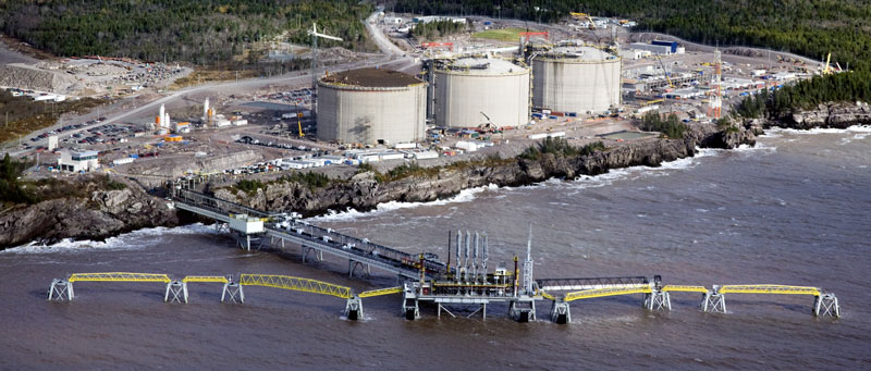
LNG Marine Terminal and Multi-Purpose Pier EIA Review
Aboriginal land & resources
To reach the aboriginal communities Irving made two phone calls on April 24th, 2002.
On the recommendation of a representative of Indian and Northern Affairs Canada, the first phone call was made to Ann Herrington. Mrs. Herington is the Aboriginal Fishery Coordinator in the Department of Fisheries and Oceans in St. Andrews. She checked with the regional fisheries officers and advised that “there is no Aboriginal fishery in Mispec Point area”.
The second phone call was made to Mrs. Megan Douglas of New Brunswick Aboriginal Affairs Secretariat. She referred Irving to Mr. Bob Stanton — who is a Senior Policy Advisor in the Department of Natural Resources and Energy. He stated that he was “unaware of any Aboriginal land use at the project site”.
Another step to reach aboriginal communities was made on January 21, 2004 — almost 2 years later! Irving “initiated” a dialogue by mail through formal letters. They were sent to the three main aboriginal councils of the region: Ormocto First Nation, MAWIW Tribal and the New Brunswick Indian councils. The two first councils did not answer. The New Brunswick Indian council did answer on March 15th, 2004. They told Irving that they have “yet to review to the information provided”.
Finally, the report states that given that there are no known current Aboriginal uses of land and resources in the assessment area, there are no known interactions of the proposed Project with this VEC. Therefore, the potential environmental effects are rated as not significant and no additional mitigation or follow-up is recommended, although Irving would continue to consult with the Union of New Brunswick Indians and other First Nations Groups. We would like to understand how they would continue to consult these First Nations Groups, as they never directly contacted them!
This part is one of the tricky points of this EIA. Only two phone calls have been made, a dialogue - or should we say a “monologue” has been set up - and finally no direct contact has been made with aboriginal communities. Irving took that as good news and went forward with the EIA — as we say, no news is good news! It is even more surprising that the public participation for example has been well done; they could have done the same for aboriginal communities.
We can say that this impact analysis has been rushed. Compare to the 727 pages of the EIA only 5 pages concern the aboriginal communities analysis (from page 657 to page 662 of the official Irving EIA report).
Archaeological and Heritage Resources
Archaeological and Heritage Resources is defined as any physical remnants found on top of and/or below ground (including the sea floor) that inform us of past human interaction with the physical environment, including architectural sites and historic places. We should note that Palaeontological resources (fossil- bearing rocks) related to the biophysical heritage are also considered.
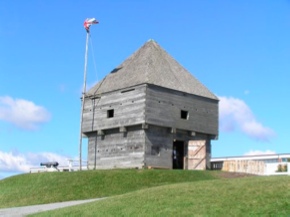
The site of the project is a region full of history. They are two main geographic reasons: First, it is a good defensive region. If you go there you can visit Fort la Tour (17th Century), Fort Howe (18th Century) and some bunkers from WWII. Second, it is an agitated maritime region. Ships sank in 1827, 1869 & 1900 and have not been found yet!
These two pictures show Fort Howe and a paleontological study area.

Therefore mitigation measures have been very well done. They have been very picky in their methods. In high potential areas their testing intervals were made every 5 to 10 meters. We should note that testing interval are function of the potential for encountering archeological sites — testing interval decreases as the potential for encountering archeological material increases. High potential areas have been defined with respect to archaeological potential indicators: availability of potable water, suitability for habitation (good ground conditions), proximity to desirable resources (workable stone), proximity to water transportations routes & portage routes.
Thus, every 5 to 10 meters they made some test-pits. Each test-pit was 50cm2 wide and excavated to the glacial till — the glacial till being the potential terminus for any potential material.
Follow-up has also been well done. In case of a finding, they would stop the construction and contact the provincial regulating agency of archaeological resources (as described in Appendix G of the Whitford report, the EPP would be followed).
Road transportation network
The main road in Saint John is the Read Head Road and its feeder. These 17km long route is the only way to access the site.
The EIA aims are to regulate the traffic and to be a safe drive zone for the public and project workers.To do that, they used two main models.
The first one is a traffic flow. The Level of Service (LOS) is an indicator of traffic operating conditions during peak traffic periods, and is based on: prevailing traffic conditions, roadway geometrics and traffic control measures placed on rural street intersections. Six levels of service are designated by the letters A to F to define traffic flow conditions. LOS A represents the best traffic operating conditions and LOS F the worst. Most urban and rural authorities will accept up to LOS D. In this EIA, they evaluated that the main road should go from a LOS B to a LOS C, the feeder should go from a LOS A to a LOS B.
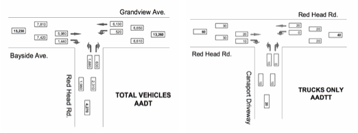
The second model calculates the Annual Average Daily Traffic & Truck Traffic (AADT & AADTT) — as you can see at left.
Just the fact that Irving and the City of Saint John did these two models is a proof that this impact has been analyzed properly. They even calculated how many cars would turn right on Bayside Avenue during a typical day!
Second, when can see how big the project is. During the construction, 60 trucks drove to the facilities every day.
Therefore, mitigation measures have been well done. They put in place car-pooling, bussing and speed limits. They also decided that during the construction all heavy material and equipment would be transported by marine transport.
To conclude we can say that, road traffic has been thoroughly considered.
Vessels Navigation
As we already explained to you in our report the Bay of Fundy is a very busy area. The local average fleet is 70 large crude carriers and 14 fishing boats, navigating in the bay every day.
During the construction, Irving used 20 to 30 barge trips to deliver all construction materials. To do that they had a 9 month “exclusion zone”. Meaning that they were the only one allowded to navigate on the bay. The “exclusion zone” is managed by the Canadian Cost Guard local authorities.
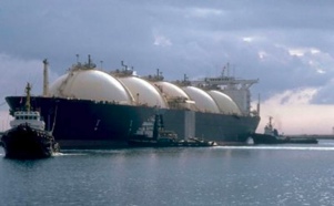
Currently, there are 80 to 120 LNG tanker arrivals per year, a massive importation of LNG, but from a local traffic point of view it represents only 8% of the overall commercial harbor traffic. And each time a vessel arrives another “exclusion road” is set up — from 24 to 36 hours depending on the size of the vessel. In other words, every 3 days an Irving LNG Tanker will arrive in the bay and will be the only one able to access Mispec point.
We can highly criticize this. As fishers can testify, the bay is now very disturbed&mdash.